
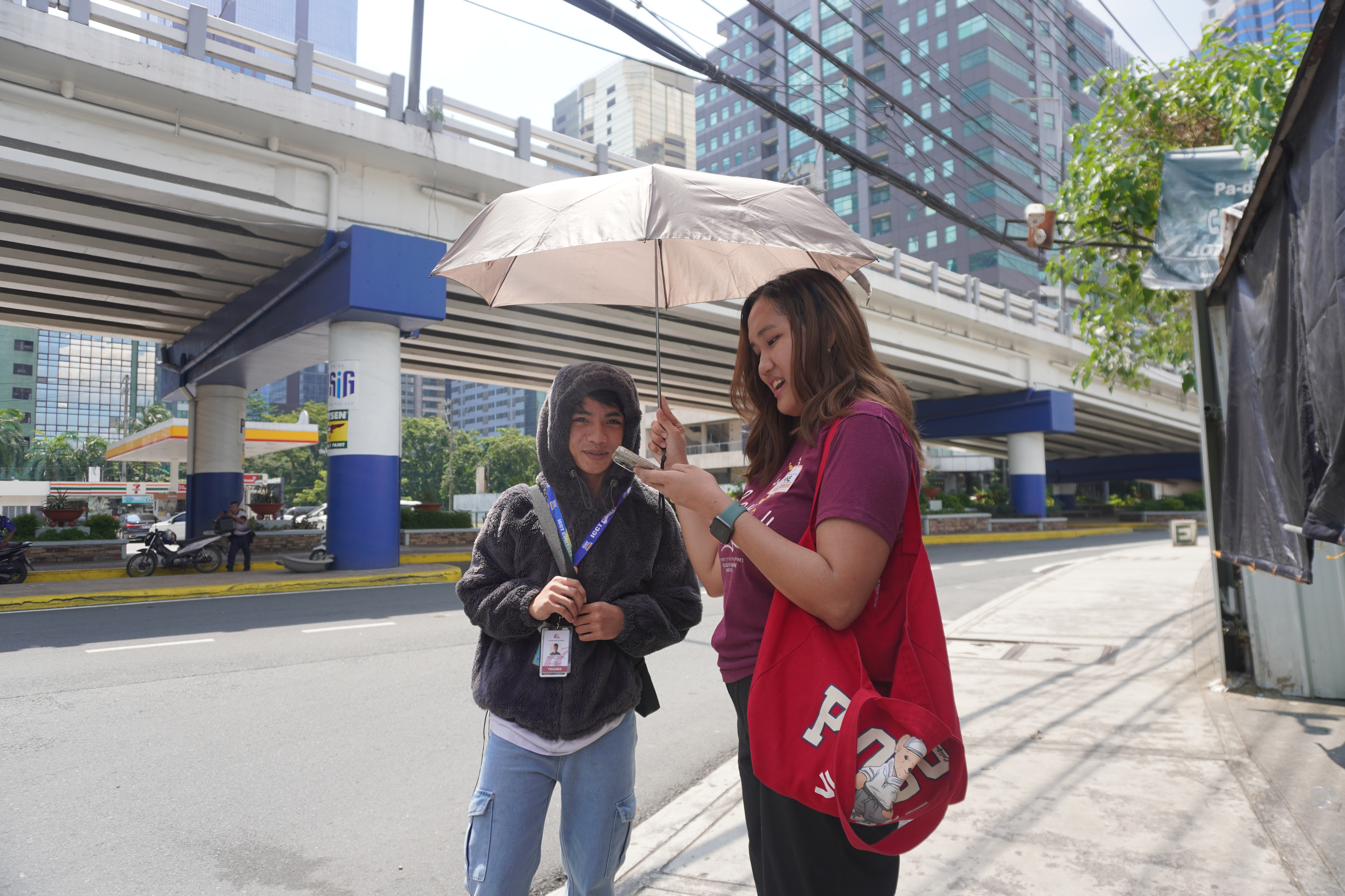
Ariane Joyce Kekim (right), one of the SPARK Project volunteers during the walkability assessments using the Walkability app in August 2025, interviews a pedestrian about the walkability of Doña Julia Vargas Avenue. Photo by Jameela Antoniette Mendoza
(An abridged version of this write-up was published at the CityTalk blog, titled “Rate this sidewalk: How community mapping turns walks into actionable data”)
Even in the age of Artificial Intelligence (AI) and promising new technologies that can digest big data for better decision-making, cities continue to face a common, fundamental challenge in urban planning: The lack of data.
According to the United Nations Human Settlements Programme’s (UN-HABITAT) “Transforming Global Urban Data” 2023-2029 report, gaps in the availability of urban data remain critically significant, representing a major risk to the design and execution of effective policy interventions and investments towards sustainable urbanization.
The lack of comprehensive, accurate, reliable and integrated data for urban planning stems from various reasons, such as incomplete datasets, siloed information across government departments, and inconsistent formats in data storage.
Gaps are particularly present in qualitative data on individual perceptions and experiences of stakeholders—an important component of evidence-based planning for cities. A study on global open data in local urban development by Sikder et al. (2025) emphasizes the importance of incorporating additional field-level data collection efforts and engaging stakeholders when validating datasets for local policy-making.
Cities are dynamic ecosystems where lived experiences can greatly inform development planning, but insufficient human resources or staffing hinders cities from deepening their datasets with qualitative data. This challenge is underscored by the International City/County Management Association (ICMA) report, “Using Data to Improve Local Government Decision Making,” which reveals that resource constraints, particularly regarding staff, not only limit the ability to conduct resident surveys and other forms of qualitative research, but also drive up the costs of data collection, making evidence-based decision-making particularly difficult for local governments.
Data gap in urban mobility planning
In urban mobility planning, there is a lack of data on walkability, which constitutes physical infrastructure (built environment) that shape pedestrian movement, pedestrian accessibility and connectivity, and socio-perceptual and behavioral information that reflects how pedestrians feel about a space, like safety and comfort.
Despite its known benefits in public health, quality of life, and environmental sustainability, walkability is still sidelined in mobility planning as car-reduced planning remains “far from mainstream” (Schröder & Klinger, 2024). The lack of accurate and up-to-date pedestrian network data remains a major obstacle in urban planning, especially as demand for sustainable transport infrastructure grows (Saberi et al., 2024, p. 1).
With the workforce in local governments stretched too thin to prioritize collecting on-the-ground data, how can cities aiming for sustainable mobility be better informed?
Here is where a participatory approach to data gathering, such as community mapping, can come in.
Community mapping has been a crucial step in the implementation of the SPARK (Sparking Active Mobility Actions for Climate-Friendly Cities) Project in two cities in the Philippines. Implemented in Quezon City and Pasig City, the SPARK Project aims to increase the role of active mobility (walking and cycling) in building resilient, safe transport systems that contribute to national emission reduction targets and promote climate-friendly mobility behaviors through community-driven strategies.
A participatory approach
One way to help address a lack of human resources in data gathering for urban planning is to break the barrier between interviewers and respondents, or planners and stakeholders, through participatory approaches. These approaches require stakeholders to be more than “subjects,” becoming part of the whole ideation, planning, and execution process of a project as decision-makers and doers.
A participatory approach fosters community ownership and long-term maintenance of initiatives, strengthens trust and partnership between government and constituents, equips stakeholders with skills and knowledge to be actively involved in planning and development, and taps into local knowledge from diverse stakeholders.
In terms of data, a participatory approach helps fill in data gaps by mobilizing stakeholders to help collect data about their own communities and deepens existing quantitative data by gathering narratives (qualitative data) on people’s experiences; providing human aspects, contextual background, and history to numbers and statistics.
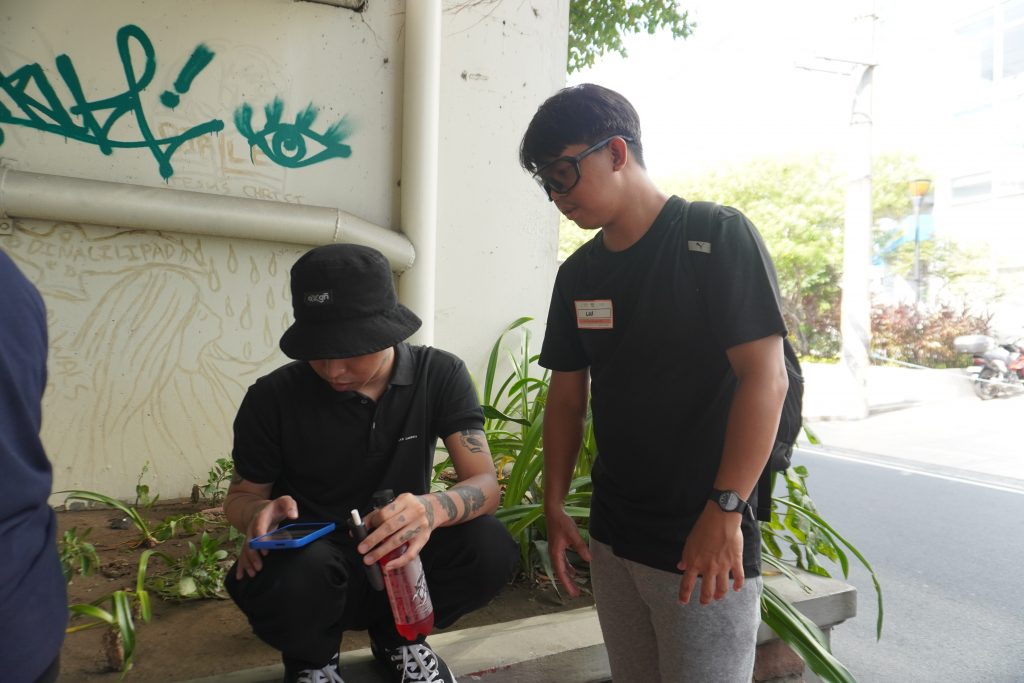
Lui Rances (right), one of the SPARK Project volunteers during the walkability assessments using the Walkability app in August 2025, guides a respondent in answering questions on the app. Photo by Jameela Antoniette Mendoza
Community mapping
An example of an activity that is participatory by nature is conducting community mapping. Community mapping is a participatory planning tool that engages target participants, usually local stakeholders, in exploring their assets within the physical and social environment. The purpose is to create a concrete output—a map, either in paper or web-based format—which can be incorporated into formal and/or informal community planning processes (UN-Habitat, 2011, p. 9). It can be as advanced as being tech-enabled through the use of Geographic Information System (GIS) and be as traditional as using pen and paper.
In mobility planning, community mapping can help pinpoint exact areas where improvements can be made and why, based on inputs from community members.
The SPARK Project conducted community mapping to assess the walkability of two project sites: Maginhawa Street in Quezon City and A. Mabini Street in Pasig City. These walkability assessments were conducted to identify how pedestrian walkways and pathways can be improved.
Walkability assessments were conducted in three levels following the SPARK walkability and cyclability assessment methodology: City-level, community-level, and site-level. Community mapping is a tool that was applied in the community and site-level assessments to ensure stakeholder engagement.
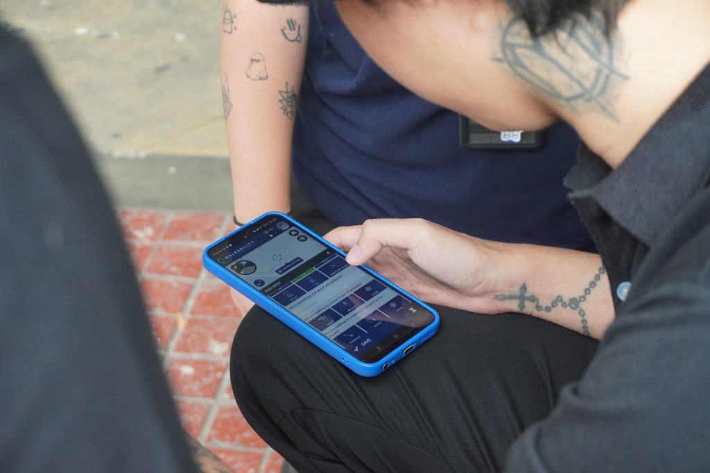
A respondent answers questions about the walkability of Doña Julia Vargas Avenue, one of the study sites in Pasig City, Philippines, during the SPARK Project’s walkability assessment last August 2025 using the Walkability app. Photo by Jameela Antoniette Mendoza.
Experience from the SPARK Project
For the SPARK Project, the first step in community mapping was a call for volunteers to conduct walkability assessments. Those who responded included residents of the project cities, active mobility advocates, and others interested in the project.
Volunteers were guided by the SPARK Project team on how to conduct the assessments, which was in the form of community mapping: Documenting their observations and experiences in specific areas on a map.
In August 2025, the SPARK Project conducted walkability assessments in Quezon City and Pasig City using the Walkability app developed by Walk21. The app, which is free to download, allows users to input their walking experience on a map. Imagine if Google Maps allowed users to leave a review of a sidewalk, a pedestrian crossing, or an intersection, instead of restaurants, hotels, or stores. When other users open the app, a map is shown with all the information left by other users. The app guides users’ “street reviews” with a short questionnaire, allowing them to assess a location based on their walking experience, including how comfortable they are walking there, how safe they feel, and what physical features of the street they like or don’t like.
The Walkability app also allows users to act as interviewers. When a user has the interviewer mode on, the questionnaire they normally see as an individual user changes to a different type of questionnaire meant to be used as a survey to gather input from other people as responders.
Using this feature of the Walkability app, the SPARK Project gathered volunteers and oriented them on how to use the app for the walkability assessments. Together with the SPARK Project team, the volunteers gathered more than 800 responses using their own smartphones in four target sites in Quezon City and Pasig City through the app-enabled walkability assessments. These responses will enrich existing walkability data at different levels gathered through different tools, helping paint a more complete picture of a street’s overall walkability.
Based on the SPARK Project’s experience, community mapping as a tool to bring in stakeholder participation in mobility planning offers several advantages to local governments:
- It is a way for local governments to gather localized, micro-level data on assets, barriers, and priorities for walkability in a location from the perspective of residents and frequent users or commuters, contributing to a richer understanding of stakeholders’ needs and evidence-based planning. This helps ensure that public spaces meet the needs of the public, effectively allocating public resources.
- Visualized data on a map is easier to understand and analyze for later use. Visualization through mapping can uncover trends that may not be seen in raw datasets. The use of an open-access digital platform like the Walkability app also makes it more convenient for decision-makers and stakeholders to access data, as the app already organizes and analyzes information within just a few clicks. This, versus the slower manual encoding and calculation of pen-and-paper surveys.
- With proper orientation, stakeholders can easily participate in community mapping, encouraging communities to be involved in local planning and governance. When stakeholders co-create solutions with their local governments, public support and trust are developed from meaningful community engagement and transparency in the planning process. Ariane Joyce Kekim, one of the SPARK Project volunteers during the walkability assessments using the Walkability app, said partnering with local organizations, community groups, and businesses strengthens community involvement.
- Active participation of stakeholders helps remind them of their shared responsibility in taking care of public spaces. Like other participatory methods, community mapping instills a sense of community and ownership, contributing to a project’s long-term sustainability. Lui Rances, another SPARK Project volunteer, said community participation in city planning and design encourages communities to help maintain improvements and abide by the policies they co-created.
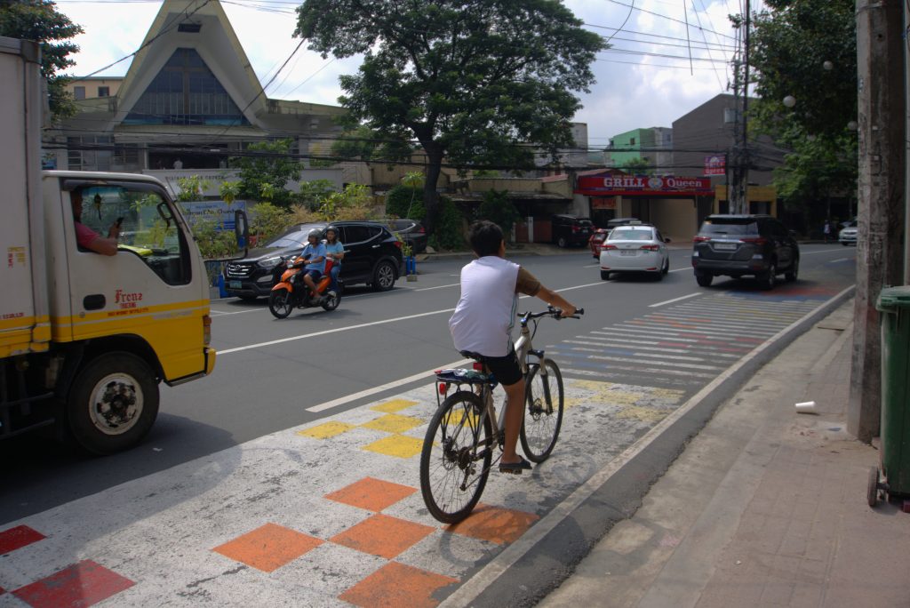
Maginhawa Street in Quezon City, Philippines is one of the sites where the SPARK Project conducted walkability assessments. Photo by Jameela Antoniette Mendoza
An appetite for civic engagement
When asked about their motivations for joining the SPARK Project team’s walkability assessment, volunteers shared a common answer: They wanted to help their city improve its streets.
The SPARK Project’s experience in mobilizing volunteers is an example of how communities, when given the right opportunity and platform, are willing to work with their local governments in improving public spaces, especially when it comes to their streets and the immediate environment that shapes their daily lives.
Community mapping can be a simple way for local governments to invite their stakeholders to participate while also addressing existing data gaps. It can be the first step in integrating more participatory tools and methods towards sustainable and inclusive mobility planning.
Written by Jameela Antoniette Mendoza


