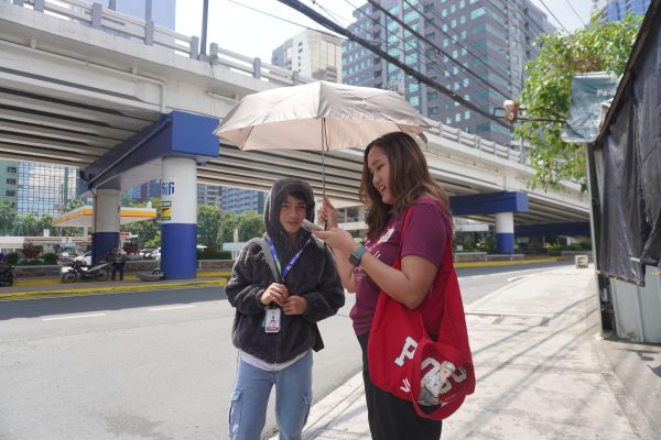
Make It Safer Movement (MISMO), a local group advocating for safer streets, organized an open mic event for the Kuwenting Maginhawa community mapping project last December 7, 2024 at Masukal Bistro in partnership with Riot Grrrl and Gedli Coffee. (Photo from: @kuwentongmaginhawa on Instagram | George Buid)
From romance to heartbreak, people shared their memories in a community mapping project to promote people-centered streets.
Maginhawa Street in Quezon City, Philippines is known for an abundance of homegrown, local eateries lining the street, offering a variety of food and drinks at various price ranges. There is a cafe, diner, or restaurant in Maginhawa for every craving, occasion, or situation. With the diversity of food establishments in the area, it is no wonder that Maginhawa is a popular destination not only for Quezon City residents but also for foodies in Metro Manila.
Over the years, Maginhawa Street has accommodated the rising number of visitors in the area, many of whom bring their private vehicles. With limited public transportation options, parking along the street eventually became the norm, with more and more people opting to use cars as they explore what the street has to offer.
As Maginhawa Street evolved to accommodate more cars, Make It Safer Movement (MISMO), a local group advocating for safer streets, launched a community mapping initiative in support of the Sparking Active Mobility Actions for Climate-Friendly Cities (SPARK) Project to remind the public of what truly keeps the street alive: its community, including residents, business owners, students of nearby schools and universities, and patrons of business establishments who frequent the area.
By gathering the community’s memories related to Maginhawa Street and the places in and around it through a community mapping project, MISMO and the SPARK Project team highlighted that what makes a place like “livable” is how well it has contributed to the lives of those who interact with it, and that shared spaces shape and are shaped by people’s lives.
Posts from the Kuwentong Maginhawa Instagram page, sharing stories of connection submitted by contributors to the community mapping project. (Photo from: @kuwentongmaginhawa on Instagram)
Sense of community
The SPARK Project is implemented in Quezon City and Pasig City, Philippines by ICLEI – Local Governments for Sustainability (ICLEI) and the Institute for Climate and Sustainable Cities (ICSC). It aims to increase the role of active mobility— especially walking and cycling—in building resilient, safe transport systems that contribute to national emission reduction targets and promote climate-friendly mobility behaviors through community-driven strategies.
To promote active mobility, the SPARK Project utilized tactical urbanism, a participative approach in urban planning and design that involves installing temporary, low-cost, and scalable street interventions to test innovative grassroots-borne ideas and gather data for long-term urban transformation.
In the context of tactical urbanism, a sense of community is crucial to mobilize people in redesigning streets and other urban areas to meet their needs and change mobility behavior.
By relating Maginhawa Street to people’s personal experiences, the community mapping initiative was also a way to remind community members of their stake in Maginhawa Street’s evolution, that they have a say in how it can be planned and designed to fit their lives; and to strengthen the sense of community among those who made memories in the area.

A post from the Kuwentong Maginhawa Instagram page. (Photo from: @kuwentongmaginhawa on Instagram)
Aside from the community mapping project, other activities organized by the Quezon City Government and local organizations in support of the SPARK Project included an outdoor dance-fitness class, a yoga class, and bicycle lessons. These free events aimed to encourage more people to enjoy the vibrant street interventions intended to promote walking and cycling and reinforce a sense of community in shared public spaces.

A participant learns how to ride a bike along the painted bike lane in Maginhawa Street, Quezon City in a free bike lesson event last March 1, 2025 organized by the Quezon City Government in line with its participation in the Sparking Active Mobility Actions for Climate-Friendly Cities (SPARK) Project. The painted bike lane is an intervention that was made possible through the SPARK Project, which aims to promote active mobility.

Elite Aerial Arts, a dance studio along Maginhawa Street, holds a free yoga class last February 23, 2025 at one of the tactical urbanism intervention sites next to the Teacher’s Village East Barangay Hall, Quezon City.
Community mapping
“Countless lives have been lived in (Maginhawa) street, but it remains as is: a street with many stories worth telling,” mentioned a post on the Instagram page for “Kuwentong Maginhawa: Stories of Connection.”
“Kuwentong Maginhawa: Stories of Connection” is a mini mapping project that aims to collect past and present stories of love, friendship, heartbreak, family, and community, with each story plotted in a map. Through this, the project shows how much relationships are built on streets that are “alive, walkable, and ultimately, for the people.”
In Volume 3 of UN-Habitat’s “Community Mapping Guide: A Youth Community Mapping Toolkit For East Africa,” community mapping is defined as a participatory planning tool that engages target participants, usually local stakeholders, in exploring their assets within the physical and social environment. The purpose is to create a concrete output—a map, either in paper or web-based format—which can be incorporated into formal and/or informal community planning processes.
UN-Habitat’s Community Mapping Guide explains that the asset-based approach of community mapping starts with counting the personal, local, and institutional assets of the community first, before counting their needs. This includes recognizing human relationships, community, institutions, and economic activity in development plans for a given location and using these assets to build an action plan.
Moreover, the UN-Habitat guide notes how mapping can give a whole new perspective and framing of one’s community, and that recognizing assets or internal resources can improve the utilization of outside resources that help meet the needs of the community.
The Kuwentong Maginhawa community-led mapping project, initiated by MISMO in support of the tactical urbanism activities of the SPARK project with the help of Maginhawa Food Community, and the Quezon City Government through Barangay Teachers Village East, invited people to share their Maginhawa Street memories in an online form. The submitted stories, associated with specific locations along and around Maginhawa Street, are then plotted as symbols on a virtual map. Once clicked, the symbols open a panel where the stories can be read, with information on the year when it happened and the name of the location where it happened, including establishments that no longer exist.

The virtual map of the “Kuwentong Maginhawa” community mapping project, where stories of connection are plotted.
The mapping project was launched in November 2024, in time for the launch of SPARK Project’s tactical urbanism interventions along Maginhawa Street in December. MISMO also organized an open mic event on the same day as the SPARK Project intervention launch, gathering people to share their Maginhawa stories in person at Masukal Bistro.

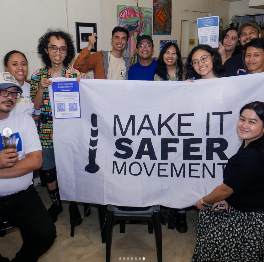
Make It Safer Movement (MISMO), a local group advocating for safer streets, organized an open mic event for the Kuwenting Maginhawa community mapping project last December 7, 2024 at Masukal Bistro in partnership with Riot Grrrl and Gedli Coffee. (Photo from: @kuwentongmaginhawa on Instagram | George Buid)

Make It Safer Movement (MISMO), a local group advocating for safer streets, organized an open mic event for the Kuwenting Maginhawa community mapping project last December 7, 2024 at Masukal Bistro in partnership with Riot Grrrl and Gedli Coffee. (Photo from: @kuwentongmaginhawa on Instagram | George Buid)
In February 2025, for Valentine’s Day, the mapping project invited people to share their Maginhawa Street stories with the theme of love and romance. The “Kuwentong Sinta: A Kuwentong Maginhawa Project” (Stories of Love) installed a physical map at the barangay (village) hall of Barangay Teachers Village East, where people could place heart-shaped stickers in locations they associate with their stories and a QR code to access the form where they can submit stories.

A map of the barangays (villages) surrounding Maginhawa Street, known for an abundance of local food establishments, shows points of interest identified by people who shared locations along and around the street wherein they have fond memories of love. The map is an output of a community mapping activity, titled “Kwentong Sinta: A Kwentong Maginhawa Project” (Stories of Love) organized by the SPARK Project team for Valentine’s Day 2025, inviting people to share love stories along Maginhawa Street.
Popular spots like Maginhawa can become more exclusive and alienating if people do not rethink how these spaces can be enjoyed and who can enjoy them. Efforts such as community mapping and activities in public spaces bring people together and serve as reminders of how popular spots like Maginhawa Street are visited by a diverse group of people, including non-car users like pedestrians, commuters, cyclists, and people with mobility issues. By making the well-loved street more accessible, it preserves the history and image of Maginhawa Street as a place that is open to all because an inclusive street is one that continues to connect people. And when there are people, streets come to life.